Community governance review of the civil parishes of Babraham and Sawston
| Name | Community governance review of the civil parishes of Babraham and Sawston |
|---|---|
| Description | At the request of Sawston Parish Council, South Cambridgeshire District Council is undertaking a Community Governance Review of the parish boundary between the parishes of Babraham and Sawston. |
| Start date | 06/04/2021 |
| Closing date | 01/06/2021 |
Background information
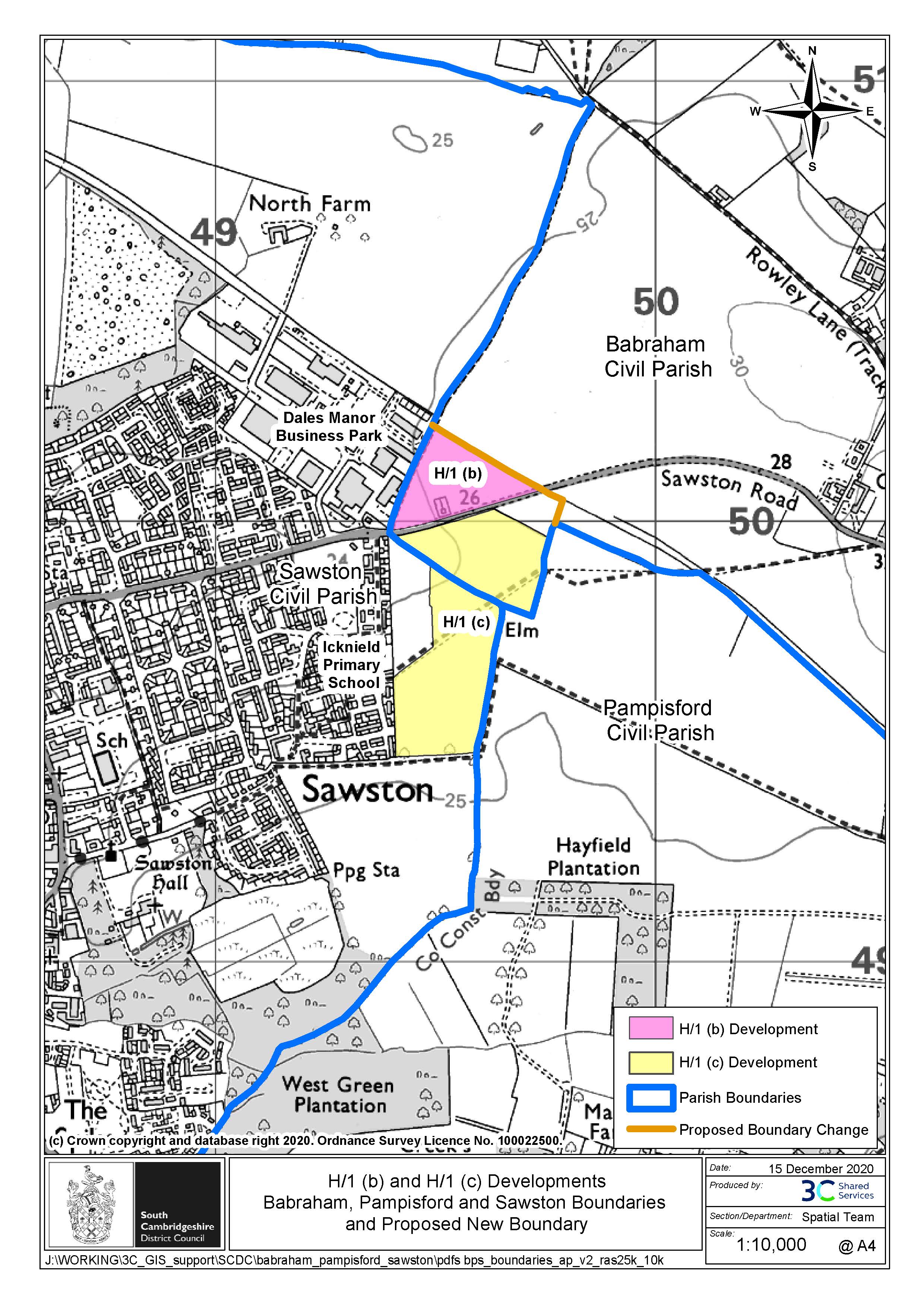
At the request of Sawston Parish Council, South Cambridgeshire District Council is undertaking a Community Governance Review of the parish boundary between the parishes of Babraham and Sawston. The Review will consider whether the parish boundary should change following two new developments:
- The development north of Babraham Road (called H/1:b) consists of 3.64 hectares and is entirely within the parish of Babraham, abutting existing Sawston properties. Planning permission was granted on 28 August 2019 for 158 homes.
- The development H/1:c – South of Babraham Road consists of 11.64 ha and spans the parish boundary of Sawston and Babraham. The Council is anticipating an application for around 260 homes. The site is allocated within the South Cambridgeshire District Plan, 2018.
Sawston Parish Council has proposed an alteration to the Babraham/Sawston parish boundary to incorporate both of these new developments into the parish of Sawston. Please take a look at the map below showing the proposed new boundary and read the Terms of reference for further details.
The review is taking part in 2 stages. Stage One is now complete – please see below for a summary. Stage Two is open for comment from 6 April to 1 June 2021 – please see below for further details.
Why undertake the review?
The Community Governance Review aims to secure an arrangement which:
- Reflects the identities and interests of the community in that area
- Is effective and convenient
- Takes into account any other arrangements for the purpose of community representation or community engagement.
It ought to result in arrangements which will bring about improved community engagement, better local democracy and result in more effective and convenient delivery of local services.
A Community Governance Review to gain the views of residents gives the District Council an opportunity to put in place strong boundaries, tied to firm ground detail, and remove anomalous parish boundaries.
Local Government Boundary Commission England (LGBCE) guidance states that parish boundaries:
- should reflect the “no-man’s land” between communities represented by areas of low population or barriers such as rivers, roads or railways;
- should consider parks and recreation grounds which sometimes provide natural breaks between communities but can equally act as focal points;
- would be unlikely to straddle a geographical feature or significant infrastructure such as a railway or motor way with no crossing points.
Whichever boundaries are chosen, they will need to be, and be likely to remain, easily identifiable.
Please refer to the map provided [JPG, 0.9MB] and Terms of reference which were published on 6 January 2021.
Stage One
Stage One of this review was conducted between January and March 2021 and invited views on the proposed boundary change as well as inviting alternative boundary suggestions. 75 residents responded to the consultation. Submissions indicated strong support for a boundary change and for the boundary change proposed by Sawston Parish Council. Three alternative boundary changes were proposed; 2 were broadly similar to the proposed boundary change and one was not supported by Local Government Boundary Commission England (LGBCE) guidance. Therefore, Stage Two considers the boundary change proposed by Sawston Parish Council only.
Results and recommendations were presented to Civic Affairs Committee on 25 March 2021.
Stage Two
Stage Two considers the boundary change proposed by Sawston Parish Council only.
The next stage of the consultation is open from 9am on Tuesday 6 April 2021 and will close at midnight on Tuesday 1 June 2021.